Rockford Map offers the most up-to-date parcel data available for over 2,400+ counties throughout the United States in .shp and .kml formats. Our fully attributed Parcel Shapefile Data contains* PINS, Ownership Information, Addresses and other related attributes. By choosing the option to receive this data in kml/kmz file format you can import it into Google Earth and view parcel boundaries and all of the other attributed landownership information the file contains. The best part is that Google Earth and Google Earth Pro are applications that are free to download.
Here are the steps on how to import parcel data into Google Earth:
1. Download and open the latest version of Google Earth on to your computer.
2. Take the sample Parcel Shapefile Data (.kmz) and save it to your desktop.
These files usually come compressed as a .zip and need to be uncompressed once downloaded.
3. Open the file in Google Earth by selecting File > Open…
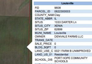 Loading this data into Google Eart
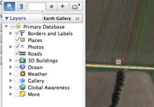 h allows you to view landownership information such as parcel IDs, parcel boundaries, and owner names right from your desktop. While you are testing out the file make sure to turn on/off the different layers to see what happens. Notice how when you click on a parcel the ownership information will pop right up! When it comes to additional data that you can load and overlay the possibilities are endless.
By using our Parcel Shapefile Data in Google Earth any organization can now implement geospatial analysis without having to spend money and have GIS software.
For more information and to view our available coverage, please visit our Parcel Shapefile Data product page or give us a call at (800) 321-1627.
* Attributes may vary by county. Most files are current within the past year.