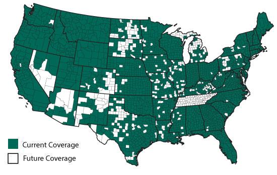
Rockford Map offers the most up-to-date parcel data available for over 2,900+ counties throughout the United States in .shp and .kml formats. Our fully attributed parcel polygon data contains* PINS, Ownership Information, Addresses and other related attributes. All data is standardized, easy-to-use structure so you can save time on cleaning up data and spend more time on what really matters. With no annual license fees, you are just one click away from data. No hassles, just parcel data when you need it now.
Don’t have GIS software? No problem. Our .kml files can be viewed using Google Earth, a free software available for download. Google Earth can be installed and used on your computer, smartphone or tablet device.
Benefits/Features
Most up-to-date parcel data available
No license fees – one purchase, no annual renewals
Import into Google Earth for user-friendly geographical analysis – NEW FEATURE
Same business day, free email delivery
Technical Specifications
File Format: .shp or .kml Common Supporting Software: Any GIS software – AutoCAD, ArcGIS, MapInfo, or Google Earth (.kml, must request when ordering) File Size: 5-20 MB per county Georeferenced: Yes Multi-layered: No Attributed: Yes Includes PINS: Availability varies by county and edition Includes Aerials: No Includes License: Yes Delivery Time: Same business day if ordered by noon CST
* Attributes may vary by county. Most files are current within the past year.