Rockford Map Publishers produces plat books and landownership maps for counties all over the country. Since 1944, we have been focused on quality and accuracy while leading the industry in plat map innovation. Here are some of the features that make our plat books and landownership maps loved by so many
 3D Aerial Maps
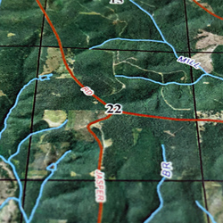
Most of the new county plat books and eBooks we publish contain facing-page aerial maps. The aerial maps are a great way to visually see what the general land use is for any given parcel (i.e. forest, farmland, city development, etc.).
As of 2017, all of our facing-page aerial maps are now 3D aerial maps! We take digital elevation model data (DEM) and merge it with our aerial imagery to create a textured, 3D aerial image. These “3D aerials” allow you to effectively see elevation change by making the map either lighter or darker based on topography. The 3D effect can be seen best in counties with large amounts of elevation change.
Index to Owners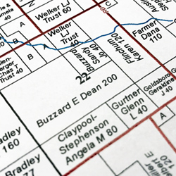
The Index to Owners shows every landowner in the county whose name appears on the township maps. To find a landowner, you can look up the landowner’s name in the alphabetical index, which will show the section and page number where the landowner’s parcel of land is located.
Since 2011, most plat books also contain a Keyed Index to Owners. The Keyed Index to Owners is what allows us to show more landowner information in the plat book than ever before. Some parcels are too small to fit anything besides acreage or the landowner’s initials. By placing alphabetical reference markers on some of these small parcels we are able to show full landowner information in the Keyed Index to Owners. This feature alone makes Rockford Map plat books much more valuable than just your standard plat book!
 Index Map
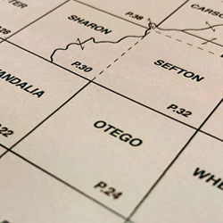
The index map shows the various townships in the county, as they are geographically located. The numbers on each township indicate the page number where that particular map will appear in detail. In our eBook, the Index Map is hyperlinked so you can actually click on a township and jump to that page. This feature is a staple of our eBooks and is one of the reasons the eBook is such a popular choice with our customers.
 Recreational Land
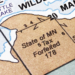
Recreational areas can be very helpful to fishermen, hunters, and many other plat book users. We consistently show and highlight more recreational land than what a standard plat book shows. This includes but is not limited to state parks, fish and wildlife areas, nature preserves, conservation areas, and public and private land. In order to maintain our high level of accuracy, we collect recreational data from over 25 federal and state sources!